A Steelhead's Journey through San Luis Obispo Streams
- Use the links at the left to download a PDF poster
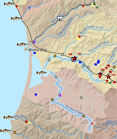
The SSRC has created this map with the California Conservation Corps. This map shows streams which have Steelhead and what affects Steelhead habitat: barriers, impediments, non-native fish and plants, and restoration projects. This GIS map is updated annually by Coalition participants and identifies jurisdiction of agencies and watershed group areas. This map is a powerful tool for people to see the "big picture" of Steelhead recovery and to identify where funding, mitigation and restoration can be most effective.
Interactive online map coming soon.
|